Delta B.C., warns residents of potential King Tide flooding, another round of winter storms expected for B.C.
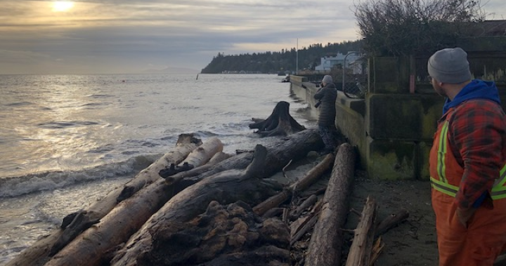
The City of Delta is warning residents to be on the watch for flooding on Tuesday due to a King Tide and gusty winds brought on by another round of winter storms.
While Monday’s high tide did not lead to any reported flooding issues, according to the City, it says another storm surge is expected on Tuesday.
Notices are being sent to residents in the Beach Grove and Boundary Bay neighbourhoods.
Tuesday’s high tides are scheduled for 9:44 a.m. and 6:30 p.m.
The City says staff will be on site to monitor the situation and respond as needed while residents are being asked to take necessary precautions.
Sand and sandbags are available at Seaview Road, 1A Avenue boat launch, 3rd Avenue beach access, and 16th Avenue beach access.
A wind warning for Metro Vancouver has ended, however a rainfall warning is in effect for parts of Metro Vancouver.
Environment Canada says two successive storms will bring 60 to 110 mm of rain by late Tuesday night to Squamish, West Vancouver, North Vancouver, Port Moody, Coquitlam, Port Coquitlam, Anmore, Pitt Meadows and Maple Ridge.
Squamish to expected to see the highest rainfall amounts, with up to 110 mm.
“Localized flooding in low-lying areas is possible. Heavy downpours can cause flash floods and water pooling on roads,” Environment Canada warns. “If visibility is reduced while driving, turn on your lights and maintain a safe following distance. Avoid driving through water on roads.”
The first storm is expected to pass through by midday Monday, while a second will hit Monday evening and intensify overnight before tapering off Tuesday evening.
There is a risk of flooding and high river levels because of ice-clogged drains and because the ground is too frozen to absorb the water.
A Pacific frontal system has also prompted a wind warning for the Southern Gulf Islands. Southeast winds of 70 gusting to 90 km/h are expected ahead of tomorrow’s frontal system while King Tides are expected Tuesday morning.
“Another Pacific frontal system is approaching south coast (Tuesday). Ahead of the front, southeast winds of 70 gusting to 90 km/h will develop over the areas adjacent to Haro Strait (Tuesday) morning. The winds are expected to ease later in the day,” Environment Canada states. “In addition, we now have high confidence in a more significant storm surge event occurring with the King Tide on Tuesday morning.”
In the wake of the second front, strong westerly winds are expected near Juan de Fuca Strait tomorrow night.
A freezing rain warning is in effect for Highway 3 from Hope to Princeton via Allison Pass. The rain is expected to end once temperatures rise Monday afternoon, but travellers can expect icy conditions on highways, roads, walkways and parking lots.
Get Best News and Web Services here