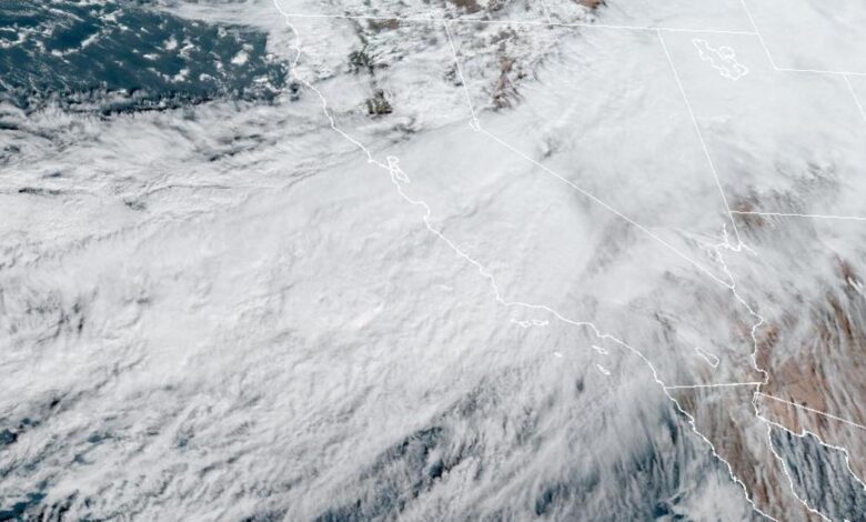
Potential Category 4 atmospheric river to hit Northern California

Southern California experienced a drastic drop in temperatures on Monday, with wet weather expected through the week, while a powerful winter storm hit Northern California started late Monday and brought several inches of rain and heavy winds.
An atmospheric river, or a weather system that moves high concentrations of water vapor outside of the tropics, could on Tuesday bring up to 1 to 3 inches of rain to the coastal areas, with higher elevations receiving upward of 3 to 5 inches, the National Weather Service told CBS San Francisco. The atmospheric river could be as strong as a Category 4, with a scale that tops out a 5.
Accompanied by a medley of weather alerts, a surging jet stream pushed the powerful winter storm system toward California’s Bay Area on Monday, CBS San Francisco reported. The National Weather Service issued a series of updated warnings targeting communities in the area, including a flood watch for cities like San Francisco, Watsonville, Pacifica, Santa Cruz, Scotts Valley and Boulder Creek. Those warnings took effect late on Monday night and are currently set to remain active through Tuesday afternoon.
By Tuesday morning, experts forecasted that significant runoff from surrounding mountain ranges could bring flooding to rivers, creeks, streams and low-lying areas, the weather service said in an advisory, adding that flooding could occur in urban areas as well as areas with poor drainage systems. Storm drains and ditches could become clogged with debris, the weather service warned.
“Locally up to 7 inches are possible over favored peaks and higher terrain of the Sonoma Coastal Range where prolonged moderate to heavy precipitation and higher rain rates are currently forecast,” the NWS told CBS San Francisco. “Last but not least, if that was not enough, there is a slight chance of thunder which has expanded southward to just around San Francisco. Not expecting much more than a rumble of thunder here and there.”
The National Weather Service said a flood watch is in effect for North Bay, San Francisco and the coastline. A wind advisory is also out for the coastal areas from Sonoma County to Santa Cruz County.
The agency’s San Francisco bureau shared updated guidance during the early hours of Tuesday morning, and, at the time, noted that “moderate to heavy rain” is anticipated throughout the day, with 5 inches expected to hit locally and between 2 and 4 inches expected along the coast. Between 2 and 3 inches of rain are expected further inland, with slightly less precipitation forecasted for valley communities, the weather service said. The advisory is scheduled to remain in effect until 6 p.m. PST on Tuesday evening.
“Localized flooding will likely occur, particularly in urban areas where ponding on roadways or poor drainage is a common issue,” weather service forecasters said. “Excessive runoff may result in flooding of rivers, creeks, streams and other low-lying flood-prone locations. Commuters should plan on a wet trip on Tuesday and allow for extra time to arrive at their location.”
Wet weather on Monday evening was already causing transportation issues on BART trains throughout the Bay Area, the agency reported, saying at the time that transit riders should prepare for delays of up to 20 minutes system-wide. The weather service noted that rain was beginning to develop in the areas surrounding San Francisco Airport at around 5:50 p.m. on Monday, according to CBS San Francisco.
The weather service has also issued a wind advisory that took effect late on Monday night and was scheduled to remain active through Tuesday morning, for coastal communities stretching from Sonoma County to Santa Cruz County.
“South winds 20 to 30 mph with gusts up to 50 mph expected,” the weather service said. “Local gusts up to 60 mph over the ridges and peaks.”
California officials warned of the potential for falling trees and tree limbs, as well as possible power outages, as a result of the wind forecast, CBS San Francisco reported, noting that beach hazard statements and high surf advisory warnings were also issued for coastal beaches due to “dangerous swimming and surfing conditions.”
Meanwhile in Southern California, the National Weather Service forecasted drastic changes in weather with temperatures dropping up to 20 degrees, as a storm system sweeps through the area into Wednesday.
“Say goodbye to the warmth,” NWS Los Angeles tweeted. “Big drop in temperatures on track between today and tomorrow (Tuesday). Expect 15-20 degrees of cooling thanks to the approaching storm system”
NWS forecasts temperatures in downtown Los Angeles are expected to drop from a high of 79 degrees on Monday to 61 degrees on Thursday, CBS Los Angeles reported.
A low-level pressure system currently forming is set to push through Washington late Tuesday and pull a plume of very moist air over California early Tuesday through early Wednesday, according to the NWS.
The plume will move slowly through San Luis Obispo and Santa Barbara Counties all day Tuesday resulting in 1.5 to 3 inches of rainfall, with some foothills like the Santa Lucias garnering up to 5 inches, the NWS said.
Ventura and Los Angeles Counties could see anywhere between half an inch to an inch of rainfall between four to six hours, the NWS said.
Meanwhile, Northwest Oregon and Southwest Washington face a storm system that is expected to bring heavy rain and strong winds starting Monday evening that could lead to minor flooding along rivers and creeks, according to NWS Portland.
“A strong frontal system brings heavy rain and strong winds to NW OR and SW WA through Tuesday,” NWS Portland tweeted. “Strongest winds along the coast, increasing tonight into Tuesday. Windy conditions inland late Tuesday morning and afternoon.”
The shift in weather comes as millions of Americans deal with a frigid winter storm that has gripped much of the United States.
CBS News has confirmed at least 62 weather-related deaths nationwide from that storm.
The scope of the storm has been nearly unprecedented, stretching from the Great Lakes near Canada to the Rio Grande along the border with Mexico. About 60% of the U.S. population faced some sort of winter weather advisory or warning, and temperatures plummeted drastically below normal from east of the Rocky Mountains to the Appalachians, the National Weather Service said.
Thousands of U.S. flights were canceled Saturday, and nearly 3,000 as of Sunday night, according to the tracking site FlightAware.
Get Best News and Web Services here


