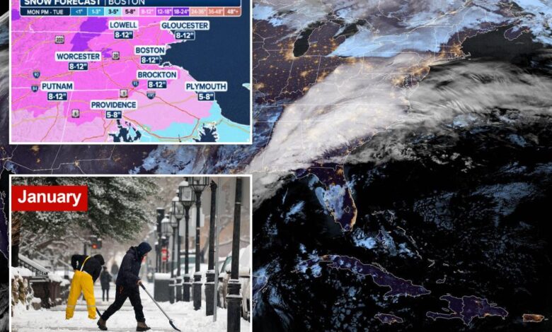
Boston, Providence under Winter Storm Warning ahead of potential nor’easter expected to bring plowable snow

The National Weather Service has started issuing its first Winter Storm Warnings across the Northeast and New England, including Boston and Providence, in advance of a potential nor’easter that could dump plowable snow on millions of people in the region starting Monday.
More than 20 million Americans across the region had been under Winter Storm Watches as forecasters began to keep an eye on computer forecast models showing the potential for a disruptive winter storm.
As those models began to come into agreement, however, the decision was made to start upgrading those winter weather alerts to Winter Storm Warnings.
As of Sunday afternoon, Winter Storm Warnings stretched from portions of Pennsylvania and New York to Connecticut, Massachusetts and Rhode Island.
The Winter Storm Warnings include cities such as Scranton in Pennsylvania and Binghamton, Elmira and Monticello in New York.
Hartford in Connecticut is also among the cities under the Winter Storm Warning, as are Providence in Rhode Island and Springfield, Boston and Worcester in Massachusetts.
Record-breaking warmth was reported across the Northeast and New England over the weekend as the storm system, which could eventually evolve into the nor’easter, takes shape across the middle of the US.
The system is responsible for producing severe weather, including large hail and potential tornadoes in Texas, as well as heavy snow across the Texas Panhandle and into Oklahoma.
It will continue on its eastward journey across the southern US, where it will again have the potential to produce severe weather and flooding in the Deep South before moving off to the northeast by Tuesday.
Moderate to heavy snow starts Tuesday
Temperatures will be warm enough on Monday that the storm will likely begin as rain across the mid-Atlantic states.
But as the system continues to advance to the northeast and eventually moves off the East Coast, it will begin to pull in the colder air from the north and Canada, which will change the precipitation over to snow.
“The storm itself, and the placement and the movement and the track is still a bit of a question as far as how it moves,” FOX Weather Meteorologist Craig Herrera said.
By the pre-dawn hours of Tuesday, widespread snow is expected across portions of New York, Vermont, New Hampshire and Maine.
Snow will also be falling in Massachusetts and Connecticut.
That means the morning commute for millions of people heading to work on Tuesday will be quite tricky and dangerous.
Schools across the region will likely be closed as the potential nor’easter begins to ramp up at that time.
Snow will continue throughout the day on Tuesday and will likely begin to pull away from the region during the evening commute.
How much snow will fall from the nor’easter?
Plowable snow is likely from this storm across interior portions of the Northeast and New England.
“Massachusetts, you’re going to be dealing with some pretty decent snow,” Herrera said. “In fact, you might be smack in the bull’s-eye for this.”
Most of the region will see snow totals of about 5-8 inches, but millions of people are at risk of seeing snow totals up to a foot, with some locally higher amounts, especially in the Worcester Hills in Massachusetts, as well as Boston.
Providence is also at risk of seeing some impressive snowfall totals from the potential nor’easter.
Northeastern Pennsylvania and the Catskills of New York could also be under the gun of seeing snowfall totals between 8 and 12 inches.
The FOX Forecast Center said the exact track of low pressure and its ability to strengthen will be key factors in determining how much snow will fall and where.
According to the National Weather Service, the primary corridor of heavy snow is expected to set up across northern Pennsylvania and southern New York before tracking into southern New England on Tuesday.
One point on the map that meteorologists focus on in determining snowfall totals is the so-called “40/70 benchmark,” located at 40 degrees north latitude and 70 degrees west longitude.
And just 50 miles to the east or west of that “sweet spot” can be the difference between an inch or two or a foot or more of snow.
As the storm approaches, computer forecast models will be able to better predict if the center of the storm’s track will be near the 40/70 benchmark, ultimately raising a meteorologist’s confidence in the forecast.
It’s not only snow that’s concerning meteorologists, either.
The NWS office in Boston said coastal flooding is a concern along the eastern shores of Massachusetts, given astronomically high tides and strong to damaging wind gusts that could occur.
Power outages, too, are a concern, as the snow could be heavy and wet, which might bring down tree limbs and power lines.
Get Best News and Web Services here


